


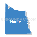
5-Voting District, Hardee County, Florida
About
Outline

Summary
| Unique Area Identifier | 553434 |
| Name | 5-Voting District |
| County | Hardee County |
| State | Florida |
| Area (square miles) | 173.12 |
| Land Area (square miles) | 172.97 |
| Water Area (square miles) | 0.15 |
| % of Land Area | 99.91 |
| % of Water Area | 0.09 |
| Latitude of the Internal Point | 27.43378700 |
| Longtitude of the Internal Point | -81.96325680 |
Maps

Graphs
Select a template below for downloading or customizing gragh for 5-Voting District, Hardee County, Florida


Neighbors
Neighoring Voting District (by Name) Neighboring Voting District on the Map
- 1-Voting District, Hardee County, FL
- 12-Voting District, Hardee County, FL
- 4-Voting District, Manatee County, FL
- 7-Voting District, Hardee County, FL
- 77-Voting District, Manatee County, FL
- 8-Voting District, DeSoto County, FL
- 9-Voting District, DeSoto County, FL
Top 10 Neighboring County Subdivision (by Population) Neighboring County Subdivision on the Map
- Myakka City CCD, Manatee County, FL (43,304)
- Arcadia East CCD, DeSoto County, FL (23,251)
- Parrish CCD, Manatee County, FL (22,183)
- Wauchula CCD, Hardee County, FL (14,689)
- Arcadia West CCD, DeSoto County, FL (11,611)
- Zolfo Springs CCD, Hardee County, FL (7,973)
- Bowling Green CCD, Hardee County, FL (5,069)
Top 10 Neighboring Place (by Population) Neighboring Place on the Map
Top 10 Neighboring Unified School District (by Population) Neighboring Unified School District on the Map
- Manatee County School District, FL (322,833)
- DeSoto County School District, FL (34,862)
- Hardee County School District, FL (27,731)
Top 10 Neighboring State Legislative District Lower Chamber (by Population) Neighboring State Legislative District Lower Chamber on the Map
- State House District 67, FL (241,034)
- State House District 72, FL (167,184)
- State House District 66, FL (162,026)
Top 10 Neighboring State Legislative District Upper Chamber (by Population) Neighboring State Legislative District Upper Chamber on the Map
Top 10 Neighboring 111th Congressional District (by Population) Neighboring 111th Congressional District on the Map
Top 10 Neighboring Census Tract (by Population) Neighboring Census Tract on the Map
- Census Tract 9703, Hardee County, FL (8,169)
- Census Tract 9704, Hardee County, FL (6,520)
- Census Tract 101.01, DeSoto County, FL (4,663)
- Census Tract 20.10, Manatee County, FL (4,019)
- Census Tract 9701.02, Hardee County, FL (3,827)
- Census Tract 104.04, DeSoto County, FL (3,270)
- Census Tract 19.14, Manatee County, FL (2,899)
- Census Tract 9702.02, Hardee County, FL (959)
Top 10 Neighboring 5-Digit ZIP Code Tabulation Area (by Population) Neighboring 5-Digit ZIP Code Tabulation Area on the Map
- 34266, FL (31,055)
- 34219, FL (17,135)
- 33873, FL (14,742)
- 33834, FL (7,448)
- 34251, FL (6,351)
- 33890, FL (5,060)
- 33865, FL (786)